CLIMBING MOUNT KINABALU
Climbing Mount Kinabalu
Ascending Mount kinabalu requires no specialized mountain climbing skills but it pays to be fit. Locals begin climbing the mountain from the age of three. The trail to the highest peak winds along the southern side of the mountain. It is an 8.5 kilometre (5.25 miles) trek to the top. For most people, from a 9 month-old baby (carried by father) to an 83 years-old New Zealander, the journey takes two days. However, champion mountain runners at the annual Mount Kinabalu International Climbathon, proclaimed the “toughest mountain race in the world”, have been known to complete the run up and down the mountain in less than 3 hours!
The terrain stretches upward from lowland rain forest to montane forest, cloud forest and sub alpine meadow, before finally reaching a crown of bare granite. Only at Mount Kinabalu can you eat breakfast in a lowland rainforest, lunch in a cloud forest, and enjoy dinner in a subalpine meadow!
A JOURNEY TO THE MOUNTAIN TOP
Timpohon Trail (6KM):
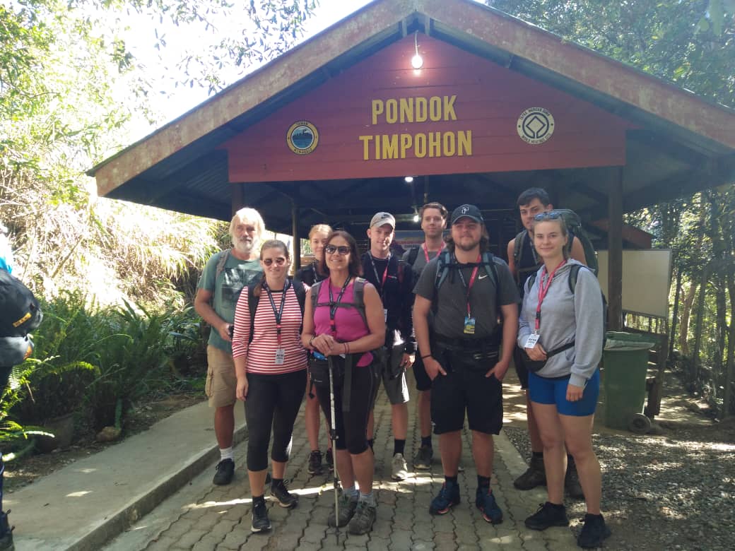
- Begins at Timpohon Gate which is 5.5 Km from Kinabalu Park HQ
- For beginners as it is equipped with clear paths to help in ascending the steep and rocky terrain
- No valleys or plateaus – endless steps goes all the way up
- Proper huts for refreshments every kilometre
- 2 – 3 hours climb to reach Layang-Layang
- 4 – 5 hours climb to reach Panalaban
Interestingly the climb actually begins at Timpohon Gate with the descent to Carson’s Fall, named after the first Park Warden of Kinabalu Park. From here onwards, depending on your fitness level, it is about 4 – 5 hours climb for the day.
The trail winds up a steep staircase of gnarled tree-roots to a mossy world of drifting clouds and orchird-draped trees, where where pitcher plants and rhododendrons abound. There are several shelters (or Pondok). The first is Kandis Shelter at 1,981 m, where on a clear day, a view of the road that links Kota Kinabalu city to the Park can be seen.
The second is Ubah Shelter at 2,081.4 m, the area where one of Borneo’s most unusual pitcher plants grows – the Nepenthes lowii, so do remember to look out for these oddly-shaped plants with containers. The mossy forest continues on past the Sabah Telecoms Station at Komborongoh, (2,252.2 m). Interestingly, ‘Komborongoh’ is a type of plant used to ward off evil spirits during traditional ceremonies and rituals by locals.
The third is Lowii Shelter at 2,267 m. The trail continues up the mossy forest of mixed bamboos and tree ferns. More rhododendrons are seen. At 2,516 m is the fourth shelter, Mempening Shelter has wild begonias growing nearby. You can stop at these shelters to observe the squirrels, tree shrews and birds that seem so unafraid of climbers. Soon after the Layang-Layang TV station, you will emerge to an open exposed ridge at Layang-Layang (previously known as Carson’s Camp). Layang-layang (Place of Swallows) is where the Timpohon Trail meets the more scenic Mesilau Trail at 2,740 m.
From Layang Layang, the journey upwards passes the fifth shelter, Villosa Shelter, at 2,691 m, which is situated at the top of an open rocky patch and soon the forest becomes even more stunted. Superb view can be seen of Mt. Kinabalu towering above you as you follow the trail upwards. As you climb higher, you will pass a forest of bent and twisted silvery-grey trunks with peeling bark.
At the top of this open area at 3,052 m, a small track leads off to a helipad on the right where you can catch a magnificent view of the Summit Plateau. Further on, you will come upon the sixth shelter, Paka Shelter, at 3,080 m. Look around for Paka Cave, which is sited on the edge of a small stream, and it is nothing more than a large overhanging rock where the first explorers slept.
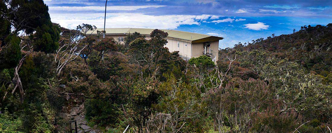
The thinning air makes it harder to breathe. Finally, the various accommodations for overnight stop are reached. The accommodations include Laban Rata Resthouse, Pendant Hut, Lemaing, Mokodou and Kinotoki Huts. You will break the journey and spend the night in one of these huts, which offer climbers hostel accommodation and a restaurant for hot meals before they resume their climb to the peak.
Panar Laban – ‘the place of sacrifice’ – was where Sir Hugh Low and his local guides performed a ritual sacrifice to appease the ancestral souls for their ‘disturbance’ to the spirit world and to seek safe passage. This same sacrifice is still performed each year and when there is a major expedition or event on the mountain.
Continue Climb to the Peak at 2.00am
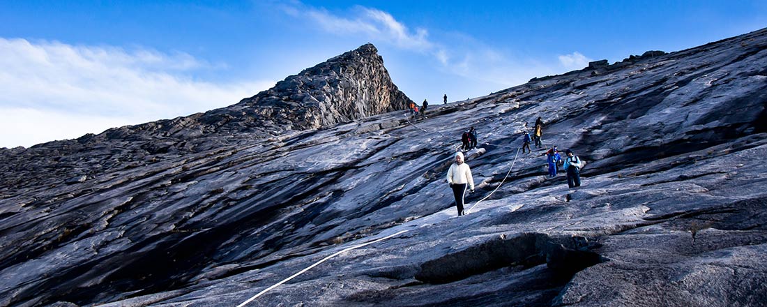
After a short night’s rest, you will need to be ready by about 2:00 am in the early morning in order to catch the sunrise at the peak. It takes about 3 hours depending on fitness level to reach the peak and there are ladders and ropes to help you over the steeper terrain. In the dark, you can see the beams of torch lights as the procession of climbers trudge higher and higher. Along the trail to the summit, marvel at the incredible mountain backdrop of teeth and fangs, rugged landscape of cliff, gorge, gulley, plateau and precipice and whatever you name it, the mountain has it!
An hour from Panar Laban, you’ll see the Sayat-Sayat Hut (3,668m), this is the highest shelter on the mountain. Your permit will be checked once again at this Sayat-Sayat Checkpoint for access to the summit and to ensure you will get your coloured climber certificate at the end of the climb. From here, you will walk across bare granite slabs that stretch endlessly ahead, in an eerie moonscape of stone.
At 4,095.2m above sea level and in the freezing darkness, you reach your final destination – the summit of Mount Kinabalu. In an almost sacred manner, the dawn of a new day unfolds gloriously before you. It is a guaranteed awesome and magical moment of your life! From this vantage point, you’ll see a dramatic drop more than 1,000m down, this is Low’s Gully.
Descent to the Foot of Mountain
It can be very cold with strong wind at the summit. Hence, climbers are advised to descend as soon as possible. You may be lucky to have good mountain condition and able to stay longer. It is however advisable to descent before the swirling clouds could obstruct visibility. It takes about 2 hours to descent to Panalaban and after you check out of your accommodation, it takes another 4 – 5 hours to descent to Timpohon Gate. The slowest descent record from Panalaban to Timpohon Gate is 12 hours!